Easy Mapping with GeoCommons
I love data mining and visualizations. I subscribe to FlowingData and pay special attention to graphs and charts in mainstream media. The power of an intuitive visualization, chart, or map can be very effective in telling a story and gleaning information.
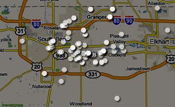
Over lunch with our Camp Fire executive director, I suggested that it would help to see the geographic distribution of our campers for the last year so we could determine where our marketing efforts should be directed. Both of our camps supplied lists of their campers’ home addresses, which is where I hit a snag: How do I generate a map with these addresses marked?
Sure, I could write a script to query Google or Yahoo! and get the latitude and longitude, generate a Google Map or Yahoo! Map and plot the points, and then apply some styles to make it look halfway decent. But that’s a pain in the butt and with all the mashup tools out there I figured someone had to have made this easier for me. Also, I’m impatient.
GeoCommons makes it easy
After some relatively quick searching, I found GeoCommons.com which lets you grab public data sets and generate custom maps. You can also upload your own data set and create a map. But I still needed to get the latitude and longitude of each record – a few hundred at least, so I wouldn’t be doing this by hand.
BatchGeocode is like magic
The demo video on GeoCommons pointed me to BatchGeocode.com to convert lists of addresses into lat/long coordinates. It’s amazing how easy it was to do – I just pasted the spreadsheet data into their box, hit convert, and it spit the data back out to me. I pasted their output into my spreadsheet, renamed some fields, saved it as a CSV, and uploaded it to GeoCommons.

GeoCommons makes it pretty
Once I uploaded my data it took about 2 minutes to create the new map, select my data, and add some styles. The options for maps, satellite imagery, etc. are great. Even better, you can pick some really nice colors, transparencies, and shapes to make your map look great. I’m a fan of any software that looks decent by default – see Apple’s Keynote for example.
Some frustrations and limitations
GeoCommons looks really usable and intuitive, and for the most part it works. But trying to figure out how to upload a data set wasn’t intuitive. To upload, you can’t go to My Sets or Maker. You can’t upload within your map. You have to go to the GeoCommons Finder section and scroll down.
I also discovered that you can’t upload over an existing data set – you have to delete it and re-upload. This is the same problem people have with YouTube – sometimes you need to fix something small but deleting and re-uploading is way more work and has too many costs.
The reason I needed to replace the data was that I had uploaded data that I wanted private. Apparently, you can access any map through a public URL. Clicking on a point on the map showed all the data from that record – a great feature if you want to share that info. But since I had checked the box to keep my data set private, I didn’t expect this to be here. So be careful about uploading private data.
Keep an eye on them
I wasn’t using any real data mining here – it was just plotting addresses on a map. But GeoCommons clearly offers more, and I’m looking forward to trying it out. It also appears that they are a VERY new service… GeoCommons was released on October 1, 2008. So I’m really excited about possible improvements – data mining tools, new visualization options, and any/all of the issues I mentioned above.
2 Comments
Andrew Turner — October 13, 2008
Glad you found GeoCommons useful – and you’re right that it’s just the beginning. Your comments are very on target, as easy as we’ve made the mapping, it can be made easier to do inline geocoding, and updating datasets.
Regarding private maps – this is something that we’ll be looking at in the future.
Chas Grundy — October 13, 2008
That’s great… I didn’t realize at first how new it was. It’s very impressive so far and I’m looking forward to even more developments. Thanks!